
New Delhi [India], September 9 (ANI): The Chandrayaan-2 orbiter which was already around the Moon captured an image of the Chandrayaan-3 lander that made a successful lunar soft landing on its South Pole.
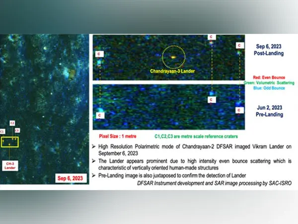
“Chandrayaan-3 lander is imaged by the Dual-frequency Synthetic Aperture Radar (DFSAR) instrument onboard the Chandrayaan-2 Orbiter on September 6, 2023,” ISRO said.
In a significant development, the Chandrayaan-2 orbiter had established a two-way connection with the lander module of Chandrayaan-3 days ahead of its soft landing in August.
Also, a NASA satellite — Lunar Reconnaissance Orbiter (LRO) – recently captured an image of the Chandrayaan-3 landing site.

The Chandrayaan-3 spacecraft is currently near the Moon’s South Pole since its successful soft landing on August 23.
India took a giant leap as the Chandrayaan-3 lander module successfully landed on the moon’s South Pole, making it the first country to have achieved the historic feat and bringing to an end the disappointment over the crash landing of the Chandrayaan-2, four years ago.
India became the fourth country – after the US, China, and Russia – to have successfully landed on the moon’s surface.
After having landed, the Vikram lander and the Pragyan rover performed different sets of tasks on the lunar surface, including finding the presence of sulphur and other minor elements, recording relative temperature, and listening to movements around it.
The stated objectives of Chandrayaan-3, India’s third lunar mission was safe and soft landing, rover roving on the Moon’s surface, and in-situ scientific experiments.
Meanwhile, the Vikram lander and Pragyan rover are in “sleep mode”, with awakening expected around September 22, 2023.
In the latest update, the Indian Space Research organisation put out a 3-dimensional ‘anaglyph’ image of the Chandrayaan-3 Vikram lander from the south pole of the Moon.

Anaglyph is a simple visualization of the object or terrain in three dimensions from stereo or multi-view images. (ANI)
This report is generated from ANI news service. The Sen Times holds no responsibility for its content.